Memory-Map app for iPhone and iPad
4.6 (
4416 ratings )
Sports
Navigation
Developer:
Memory-Map
Free
Current version:
2.4.0, last update: 1 year ago
First release : 10 Feb 2010
App size: 4.7 Mb
Turn your iPhone or iPad into an outdoor GPS or marine chart plotter, with the detailed Topo maps or NOAA marine charts needed for your activity. Maps are stored on the device for offline use, when you dont have any network connection. The GPS will show your location even where you have no mobile phone signal.
The app can be used standalone, but the maps and overlay data may also be used on your home PC or Mac for planning, and for printing maps on paper. Then upload everything to your phone or tablet and enjoy navigating outdoors with high quality maps.
When you get home you can transfer your tracklog and points of interest back onto your computer, to see where you actually went, analyze your speed and elevation profile, and so on.
Whether you are fishing, paddling, backpacking, mountain biking or sailing, enjoy your time in the wilderness with Memory-Map. We have been developing mobile navigation apps since year 2000, and our products are trusted by mountain rescue teams, police and coast guard stations around the world.
Features:
+ Fast scrolling and zooming
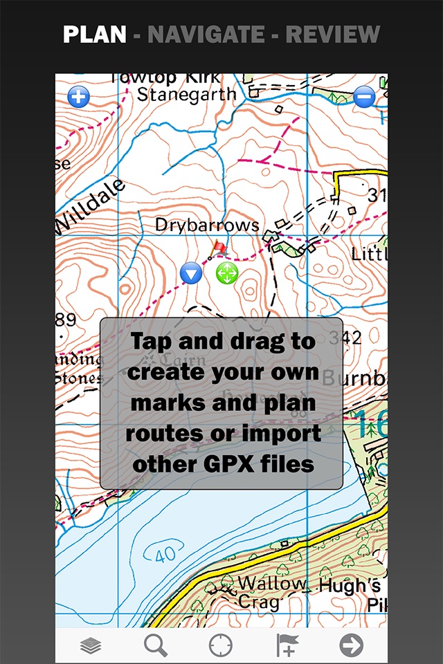
+ Import and export GPX files
+ Screen lock to prevent accidental screen touches while recording a track
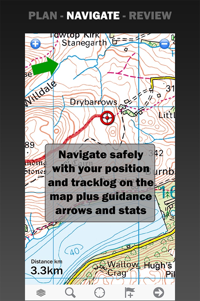
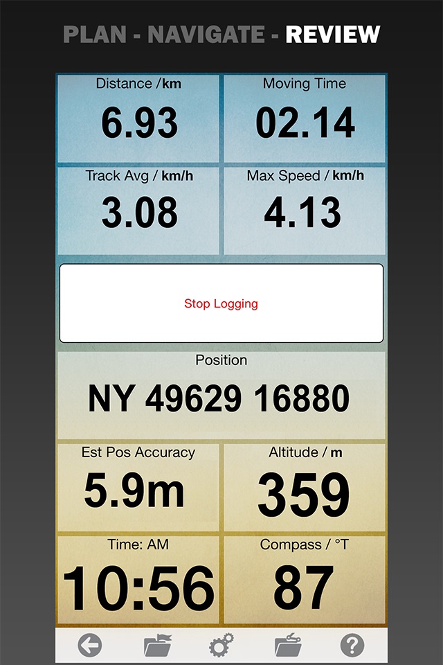
+ Shows speed and direction of travel, even while walking slowly
+ Support for GPS and Compass sensors, where available.
+ Placename index, works offline
+ Moving map, lock GPS position and automatically scroll the map
+ Records tracklogs with app running in the background
+ Create and edit marks, which may be linked to a web URL
+ Plan routes, measure distance and bearings
+ Routes snap to roads or trails, optimized for walking, cycling, or driving
+ Shows Altitude
+ Lat/Long, UTM, British National Grid and MGRS coordinate systems
+ Share position marks or tracklogs with other apps using GPX files
+ Connect to NMEA instruments and AIS via a WiFi gateway
+ AIS collision alarms, Anchor alarms and proximity alarms use notifications.
Battery Use Disclaimer: "Continued use of GPS running in the background can dramatically decrease battery life."
Pros and cons of Memory-Map app for iPhone and iPad
Memory-Map app good for
After buying about 6 navigational applications for my iPhone I finally got one that really works the way it should. I could send my PeeCee version of my Memory Map converted charts to my iPhone and I now have a handheld version of my sailboats navigation system.
I am very happy with this app and would recommend it to any avid sailor.
This app is extremely simple you will need to spend some time to familiarize yourself on its operations but it couldnt be simpler. Ive actually started use it as a go between when doin research for reef fishing or as a backup and have had to use it as such. Total life saver and worth every penny. Would like to have additional offshore maps and inshore maps with increased detailed overlays.
I have owned Memory-Map apps for several years. I reviewed Memory-Map last year and rated it as 5-stars. On a trip to Patagonia last month, it performed flawlessly, It is still my best off-road navigation app, even though Apple bureaucracy has un-necessarily rendered its best features (including on-line purchases) inoperative with this "upgrade".
Go ahead and buy it if you havent yet purchased it. You will likely not miss what Apple has disabled.
If you already own it, I recommend you not upgrade until Apple sorts out some of its issues with this app.
I have used Memory-Map for marine navigation for about 10 years, first on my laptop, then on a PDA, and now on my iPhone 3GS using version 1.5.0 of this app. Yes, there are a few things Id like to see changed, but it works better and is MUCH cheaper than any of the 3 other Nav systems I used before this.
You can get USA marine charts for free from NOAAs download site. These raster scanned charts are updated as needed by NOAA. For charts of waters outside the US, you may have to buy them from commercial sources. (For my sailing in the Caribbean, I still use old raster charts I got 10 years ago. They still serve well because those islands dont move around much from year to year!)
It is great to have a moving chart plotter on board (my iPhone) that I can hold in my hand!
I recommend this app (ver 1.5.0) to sailors old and new.
I use this app quite a bit for boating & hiking, found it to be the best for noaa & USGS topo maps when out of 3G area. You can pre-download entire areas of maps fairly easily which is necessary when in the back country or on the ocean. When you use the mobile version in conjunction with their PC software its very nice keeping track of waypoints, routes and tracks. Import/export works well. Marine NOAA maps are free to download, but you have to pay to get many other maps (USGS topo, Delorme, etc). But for ~$20 or so per map region I dont think its that unreasonable though.
Ive compared many other topo apps, all of which seem to be lacking one feature or another. Memory map is worth the $$, but also lacks needed features. I end up having to use use it in conjunction with other apps, which is do-able but inconvenient. Would be much better if they could add a couple additional features, namely: 1) need ability to take photos within the app & tag them to waypoints/tracks... 2) Add 3D view (which is available in the PC version), or at minimum an option to view shaded relief via elevation data. Viewing topos in 3D/shaded relief really helps a ton, and seems itd be fairly easy to add since they already have all the elevation data.
Overall good app, just needs more features
Found trails that I didnt even know where there. Navigation features work really well and I was able to design several routes right off the bat. excellent
Some bad moments
Bought this app to help in accessing NOAA charts for florida/ Sanibel/Ft.Myers. I tried to download the Raster Maps and despite several hours of effort could not get them to work. To transfer from a MAC to an iphone was definitely an exercise in frustration, After 21/2 hours I gave up. I could not contact support and could not resolve the issue. For 29 it was indeed a waste of money. As I was going out in a boat the next day I searched a bit more and found an app by Navionics for$ 9.95. Up and running in 5 minutes an intuitive. Better value for the money and I did not need a PC/Mac to download the maps. The navionics was standalone where as Memory Map was not.
As I could not get it to work properly I cannot give anymore input to this program.
Alot of hype. Cant even find maps for straight of Georgia off of Vancouver island. Waste of money
Downloaded this app, within two minutes constant prompts to buy more maps. Loses locator. Totally useless!
I updated to 1.6.1 after map loading issues with my older version. This version re-enables my third-party maps to be identified and loaded in the app. BUT, it appears to be only a 5-day activation! And the "Buy one Import 3rd Party maps" is listed at $28.99 CAN! The programmers should not implement poorly-documented changes in the way the app handles - and charges for - digital maps. For this added cost, the total price for the Memory Map package exceeds that of more capable navigation apps.
The app erased all the included maps of England. And others that I enjoyed. It also wiped out every map on my iPhone . All you have left is a crappie fake topo map. Leave it the way it was.
The maps are REALLY outdated. Cmon guys, I 220 was built in Shreveport what, ten years ago? If tour looking for current maps, dont look here!
Usually Memory-Map iOS app used & searched for
caa app,
os maps,
topo maps,
topographic maps,
and other. So, download free Memory-Map .ipa to run this nice iOS application on iPhone and iPad.